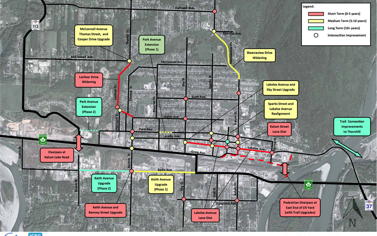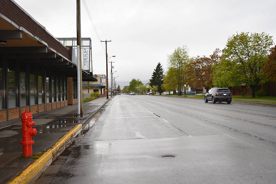
IT’S good-bye four lanes on Lakelse Ave. and hello to two lanes with a both ways turning lane in between, city council has decided in approving one of the more dramatic traffic flow changes in decades.
The intent is to create more space between moving vehicles and those that are parked and so reduce accidents when people are exiting parked vehicles, McElhanney Consulting engineer Glenn Stanker told council in presenting it with his company’s master transportation plan for the city.
“I looked at the level of service and you’re not going to observe any delays,” said Stanker about the change to three lanes.
The conversion to three lanes would take in all of Lakelse from its T-intersection with Eby at city hall east to Apsley Street.
The three-lane pattern would be the same as it is now on Kalum starting at Davis and continuing northbound.
At 17 metres wide, Lakelse Ave. isn’t wide enough for both four lanes and parking, the study indicated.
“There is insufficient road width for the current laning, as is evident from the concerns about weaving, turning, and parking conflicts. This will become a growing safety concern as traffic and parking demand increase,” stated the study.
The shift to one lane each way and turning lane in the middle is called a “lane diet” in traffic engineering circles.
Although the Kalum Ave. three-lane configuration does have painted bike lanes there simply isn’t enough room on Lakelse Ave., Stanker said.
City officials are anticipating the Lakelse conversion to take place as soon as ICBC conducts a safety review.
How motorists will take to the Lakelse lane change won’t be known until it actually does happen but there were a few complaints registered about the Kalum three-lane configuration held at an open house leading up to the master plan completion.
Mayor Carol Leclerc agreed that the Lakelse Ave. conversion project should be the first one on the city’s list because it’s the easiest one to accomplish.
“We’re going to pave the lines anyway so it’s not a cost item,” said Leclerc.
“[The road] is going on a diet to make people safe,” she added, referring to McElhanney’s term “lane diet”.
The transportation master plan has been a little more than a year and a half in the making and was commissioned by the city based on an anticipated population increase of 50 per cent should large scale development take place.
“Irrespective when this growth happens, what we’ve done with this plan is show how the city can address stresses on the transportation in the city due to growth whenever it happens,” said Stanker.
He looked at a number of plans the city had already commissioned over the years, adding the plan takes in open house comments, meetings with specific user groups and public agencies and the results of an online survey.
ICBC participated to the extent of providing money to widen the plan’s scope to examine the top 2o intersections at which collisions occur.
In addition to changing traffic flow on Lakelse, the study clearly identified the Keith and Kenney intersection on the southside as a problem that requires a four-way stop.
“It needs to happen, it’s warranted and has a collision history that supports it as well,” said Stanker in calling a four-way stop there a “no brainer.”
Also making the top priority list is widening Lanfear Hill up to the Bench.
It would be very expensive but be money well-spent if there is any population growth on the Bench, said Stanker, adding that Lanfear is a key conduit between the Bench and the rest of the city.
“Lanfear certainly makes sense to be looking at especially if we’re going to have the growth on the Bench,” said Leclerc.
She noted that residents in that area did make a presentation to council with their concerns about development on the Bench and its effects on traffic flow.
Never far from the public debate is a second overpass over CN’s tracks and this McElhanney study will ignite that again with including the prospect of one at the intersection of Hwy16 and Hwy113/Kalum Lake Road.
“It makes so much sense to put it down by Braun Street (on the Southside) to tie it in to the Kalum Lake Road intersection,” he said.
“It makes the truck route work, it connects to the highway system better and topographically makes sense. The land use impacts at this point are far less.”
In speaking to council Stanker did concede most people will talk about putting an overpass in at Kenney St.
But that would take away a viable existing level crossing, he said.
By putting an overpass in at another location, motorists will have that benefit as well as the Kenney St. level crossing, Stanker continued.
While any overpass will improve reliability and safety, there’s the benefit of added capacity, Stanker said in advocating for an overpass at Kalum.
He said there’s three objectives: safety, reliability and capacity – while any overpass will improve reliability and safety, you get better capacity if you increase the number of crossings.
“That is our recommendation and I think previous studies support that as well,” he said.
The traffic overpass is a longer term project, says Leclerc, saying it would be closer to $30 to $40 million and need to be done in conjunction with the federal and provincial governments and maybe CN.
Not regarded as economically feasible is the call for a pedestrian bridge to span the rail tracks at the foot of Kalum and so provide a safe way to connect the Southside.
“We looked at that quite seriously and came up with the idea to make a bridge the way it was envisioned where people want to cross,” he said. “The estimate is in the order of $14 to $15 million, just an obscene amount of money.”
“The punchline of this for the cost of this [bridge], you could pay for almost every other improvement in the study, except the Kalum Lake Road overpass.”
If the city really needed a crossing over the railway tracks at Kalum Street, there is the possibility of using gondolas, which are used in other countries and would be a fraction of the cost, Stanker said.
And if the city does want to pursue a pedestrian bridge, Stanker said a much better location would be at the eastern end of the CN rail yard toward the Skeena River.
“This already to some degree has been planned in the active transportation plan,” said Stanker.
He considered a pedestrian bridge over the CN tracks and the widening of Lanfear Hill as equally important.
“Lanfear of course, you haven’t had safety issues in collision stats but you do have school children walking up the hill and people wind their way down the steep grades faster than they should,” he said.
“You don’t want to wait for those to happen before you deal with it. Both are very high in priority.”
Terrace is at a time in its development where the city can make good choices and generations to come will benefit from the choices made today, said Stanker. McElhanney’s study cost the city about $60,000 to $70,000 and the city has grant money to pay for about 80 per cent of it, said Leclerc.