In the late summer of 1944, a highway that hugs the river on one side and has a wall of mountains on the other, was officially opened. This was the Skeena River Highway. After years of cutting through bushes and chipping away at hard rock, Prince Rupert had finally established a road to Terrace.
In 2019, it is almost hard to imagine that this drive, dubbed as one of the most beautiful drives in the world, was built because of a worldwide, life-changing event that caused so much grief and pain.
The Skeena Highway, spanning from Prince Rupert to Terrace, was one of the larger projects to come out of the City of Prince Rupert during the war. Having officially opened on Sept. 4, 1944, the Skeena will also celebrate its 75th anniversary this year.
After years of the federal and provincial government tossing around the idea of establishing this link between both cities, the perceived threat of a Japanese invasion is what finally pushed them to build the highway along the Skeena River.
It was the presence of the American army in Prince Rupert that convinced both levels of government that an alternative road was needed in the event that the troops had to retreat to interior of B.C.
Off to a rocky start
Conception for the idea first began in the early 1920s but finding the perfect route proved to be a long and bumpy ride.
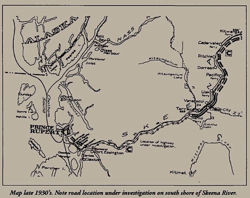
The first aerial photographs in the region were actually taken by a Public Works crew scouting out a possible route for their highway but they came up empty handed. Several years later a route was considered to go up from the Skeena River to Work Channel crossing through the mountains all the way to Exstew River then back down to the river until the road hit Terrace. A year later more aerial photographs were taken but it was concluded that any road not following the Skeena River would be nearly impossible to construct.
In the 1930s the first gravel road from the harbour to Galloway Rapids was built. The next phase was the construction of the bridge, establishing a connection to Port Edward on the mainland. The project continued up to Prudhomme Lake until construction was halted at the onset of WWII.
Top Priority
The American military began reinforcing Prince Rupert in 1942 when the threat of a Japanese invasion seemed more imminent. Fortifications were put in place and the road became a top priority.
Initially, U.S. and Canadian military authorities attempted to build a road from Prince Rupert to Hazelton in one year, a massive project which had never been attempted in the country in such a short timeline, according to Dirk Septer, aviation and B.C. historian.
The highway was divided into five sections. Eight railway crossings needed approval from Prudhomme to Tyee, cracks filled with muskeg had to be shovelled out and filled with rock, and 45 bridges were built in Vancouver for the project. To top it all off, the region’s infamous rain season slowed down production and scared off many workers.
“Twenty-four hours a day, seven days a week at sometimes in excess of $60,000 per mile, eight contracting firms worked to put in a highway through one of the world’s toughest terrain of granite mountains,” described one Vancouver newspaper.
Although the project employed many men before and after the Depression, historical records showed that the average worker only lasted 60 days before quitting in frustration.
But on Aug. 4, 1944, a month before the official opening, all their hard work came to fruition as Private Buddy Bodzash drove the first car over the new link between Prince Rupert to Terrace. Col. D.B. Martyn, Commanding Officer of Prince Rupert Defences and his wife, were Bodzash’s passengers on the journey.
“I came to Skeena Country 37 years ago with a packsack on my back and have worked all those years to get a highway. Now Pearl Harbour has brought it about,” said Skeena MP Olof Hanson as he cut the ribbon on opening day, according to an account by the late historian Phylis Bowan, in her book “Road, Rail And River!”
Nearly 100 people drove the highway to Terrace that day. But the road would face many problems in the years to come. Landslides destroyed parts of the drive, and once the war was over no level of government wanted to take responsibility for maintaining the route.
It was a long a windy road to get the Skeena we know today — but the war was the driver to pave the way to what would eventually become one of the most scenic routes B.C. has to offer.
Jenna Cocullo | Journalist
Jenna Cocullo
Send Jenna email
Like the The Northern View on Facebook
Follow us on Twitter